
Welcome to Paria's “Hike of the Week” series. Each week, we highlight one of the most scenic or challenging trails from around the country. For us, just reading about a great hike is motivation enough to want to get out there and explore it ourselves. We hope these write-ups do the same for you!
This week takes us to the remote North Coast Trail on the northern end of Vancouver Island, Canada.
Why Hike the North Coast Trail?
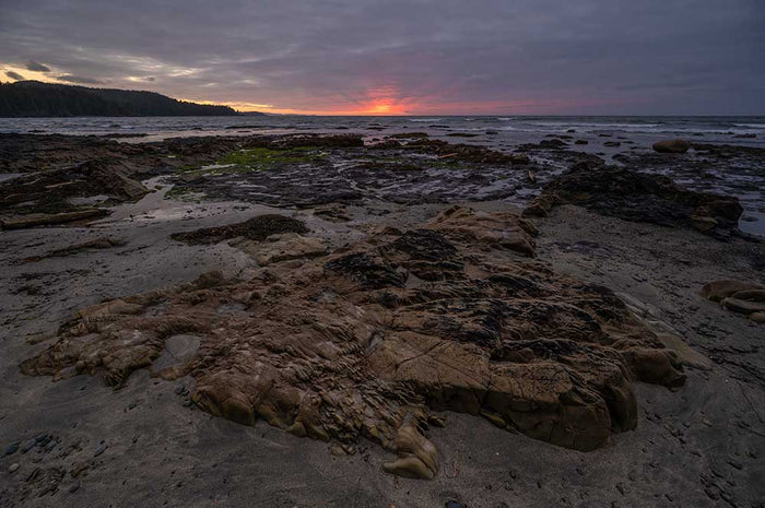
The North Coast Trail has stunning beach views with the potential for some breathtaking sunsets. With old growth forests, challenging bogs, and amazing wildlife, the North Coast Trail (est. 2008) is quickly making a name for itself as a premier destination for coastal hiking.
- Distance: 36.7 miles (though our itinerary to Nels Bight and the Lighthouse will add miles to your trek)
- Max Elevation: 797 feet
- Total Elevation Gain: 4,672 feet
- Time: 4-7 Days
- Best time to hike: April to October. Summer temperatures typically range from around 63 degrees Fahrenheit during the day to 48 degrees at night.
- Main campsites include pit toilet and food caches
- Wildlife is prevalent on this hike. Be on the lookout for bears, wolves, whales and other creatures.
- There is no cell phone service on this hike so plan your route accordingly.
- Optional add on day hike to Cape Scott Lighthouse (from either Nels or Nissan Bight)
- Inland trails from beaches are well marked with hanging buoys.
- There are two cable cars, plenty of boardwalks, stairs and anchored ropes to assist you on the hike.
- There is an impassable area of beach at high tide on the second day of hiking. Have knowledge of the tide charts for that day to avoid getting stuck waiting for the tide to change.
How Do I Get There?
The North Coast Trail is accessed via Port Hardy on Vancouver Island.
The Closest Major International Airport to Port Hardy is Vancouver International Airport (YVR). You can choose to drive or fly to Port Hardy from here.
Pacific Coastal Airlines offers flights from Vancouver (YVR) to Port Hardy. Check out their website for available flights.
You will need to take a ferry to Nanaimo if driving from the greater Vancouver area. There are two ferry terminals in the greater Vancouver area: the Tsawwassen Ferry Terminal in Delta and the Horseshoe Bay Ferry Terminal located in Vancouver. You will want to use the Horseshoe Bay Ferry Terminal if traveling from Vancouver International Airport.
To get to Horseshoe Bay you will need to take the Trans-Canada Highway (Highway 1) westbound to Horseshoe Bay Ferry Terminal. From here you will need to take the ferry to Nanaimo (Departure Bay). Visit BC Ferries to check available sail times and to reserve your spot on the ferry.
The Horseshoe Bay to Nanaimo (Departure Bay) ferry is approximately 1 hour 40 minutes long. The Tsawwassen to Nanaimo (Duke Point) ferry is approximately 2 hours long.
Once you depart the ferry continue straight onto the Trans-Canada Highway (hwy 1). Use the right two lanes to turn right onto Brechin Road. Follow Brechin Road to Highway N/BC-19A N (Island Highway North). Stay on the Island Highway for approximately 229 miles (368 kilometers), then continue straight onto Douglas Street/BC-19. Turn right on Granville Street.
The entire trip by vehicle is approximately 296 miles (477 kilometers) long (driving only) and takes approximately 7 hours and 5 minutes (including ferry time).
Most hikers tend to hike the North Coast Trail from East to West (starting in Shushartie Bay and ending at Cape Scott Trailhead parking lot). A water taxi is required to start the trail at Shushartie Bay. The Cape Scott Water Taxi is located at 6555 Hardy Bay Road in Port Hardy. A shuttle bus is also highly recommended to take you from the Cape Scott Parking Lot to Port Hardy once you finish the trail. The water taxi and shuttle must be reserved ahead of time. You can book your spot on the water taxi and shuttle at the Cape Scott Water Taxi website.
Cape Scott Water Taxi service is available from April 15th to September 30th though the first and last two weeks are weather dependent. The trip from Port Hardy to Shushartie Bay is approximately 1 hour by water taxi.
The water taxi departs at 7am meaning you will likely need to find accommodation in Port Hardy prior to leaving for your hike. The Quarterdeck Inn and Marina and the Glen Lyon Inn are two hotel options close to the water taxi. There is also the North Coast Trail Backpackers Hostel which is a popular choice amongst travelers.
Map of Recommended Route
The following map outlines our recommended route. Click the "Load Interactive Map" button to load the correct map. Once loaded, you can navigate along the route and view recommended campsites.
For even more detailed mapping, including being able to print a copy for yourself, click the "Open in CalTopo" button at the top of the map once it's loaded into view.
- Day 1 - Shushartie Bay to Skinner Creek
- Day 2 - Skinner Creek to Cape Sutil
- Day 3 - Cape Sutil to Irony Creek
- Day 4 - Irony Creek to Laura Creek
- Day 5 - Laura Creek to Nels Bight
- Day 6 - Optional day trip to Cape Scott Lighthouse
- Day 7 - Nels Bight to Cape Scott Parking Lot
Trail Description
Day 1 - Shushartie Bay to Skinner Creek
There are no boat docks for the water taxi at Shushartie Bay. Instead the water taxi will maneuver the boat as close as possible to a rocky shore at which point you will be asked to exit the boat from the bow. Be careful as the rocks are slippery. Once past the rocky shoreline there will be a large sign marking the beginning of the North Coast Trail. This is a good place to take a picture marking the beginning of your trek. From here you will be greeted with a steep incline. Of note, there are sections throughout the North Coast Trail where you will be provided a rope (which is already secured and ready to use) to assist with an ascent or descent of particularly steep sections. This first section of the trail will be one such area where you may need to use the assistance of a rope to climb.
The majority of your first day will be spent navigating mud pits where you may find yourself looking for tree roots or logs sticking out of the mud to traverse. There are many deep mud pits that can swallow your boot if you aren't careful. The suction power of the mud could lead to some tough slogging if you try to power through the middle of these obscene pits of despair. There are a few boardwalks to break up the constant slog however you may find yourself wishing for a few more of them on this day. Even in mud-less sections you will find yourself stepping on, over and around numerous tree roots that cross your path. Day 1 is definitely a strenuous day, being both mentally and physically exhausting.

You will conclude your day with a descent to your first camp site at Skinner Creek.
Day 2 - Skinner Creek to Cape Sutil
The second day will provide yet another challenging day of hiking. Fortunately, you are eased into your day. You start by hiking along the beach at Skinner Creek until you reach some buoys marking the start of the inland trail. This initial inland section of trail (to Nahwitti River) is relatively easy compared to the day before. This part of the North Coast Trail does not have the constant barrage of mud pits making it easier to hike quickly. Eventually you will descend to a gravel beach which leads to the Nahwitti River Camp.
You will travel inland once again after leaving the camp area and will quickly come across the first of two cable cars on the North Coast Trail. This cable car passes over the Nahwitti River. The hiking today will become much more challenging after the cable car with more tree roots and mud pits to work around. Eventually you will come across wooden stairs leading down to Tripod Beach. The west side of Tripod beach has an impassable area at high tide with no alternate inland route. Pay attention to the tide charts prior to hiking the North Coast Trail or risk getting stuck waiting for the tides to change.
The remainder of today's hike involves steep ascents and descents into pocket beaches though you may be able to pass some headlands along the beach if the tide is low enough. After the final headland you will encounter a sandy beach. The Cape Sutil Campground is just a short walk up the beach with Cape Sutil itself being the Northmost point on Vancouver Island.
There is a Yurt at the Cape Sutil campgrounds that is sometimes occupied by park rangers between June and September.
Of note, some hikers will travel from Shushartie Bay to Cape Sutil in 1 day in order to get through the most difficult stretch of the North Coast Trail as quickly as possible. However, you will need to be an experienced hiker with good pace to hike this section in 1 day and it is therefore recommended that most hikers complete this section in two days. Fortunately, the North Coast Trail does get significantly easier after Cape Sutil. In fact, some people choose to forgo the first 2 days and start their hike at Cape Sutil. This can be arranged through the Cape Scott Water Taxi for an additional price.
Day 3 - Cape Sutil to Irony Creek
Today’s hike will be mainly on the beach though this is broken up with small sections of inland forest. Stay on the lookout for buoys marking the trail while hiking along the beach which mark the inland sections of trail. There are steep inclines to many of the gravel beaches with plenty of seaweed to walk around.
Irony Creek at Shuttleworth Bight is one of the jewels of this hike with the campgrounds being a step up from the previous two nights. There is plenty of driftwood near the water source and the beach is incredibly long though it can get narrow during high tide.
Day 4 - Irony Creek to Laura Creek
This day starts with a relatively easy jaunt along the sandy beach of Shuttleworth Bight. There will be buoys near the end of the beach marking the start of the inland section. Once inland, you will quickly come upon the second cable car which spans across the Stranby River. The trail will stay inland for approximately one mile and then you will enter a stretch of pocket coves between short overland trails.
Many of the beaches will be full of pebbly rocks that are loosely packed which will make your feet sink or shift while trying to push off. In addition to this, there are steep inclines to many of the beaches and plenty of seaweed to maneuver around.
You will end the day with a short inland section before shooting down to the beach at Laura Creek.
Day 5 - Laura Creek to Nels Bight
This day begins in a similar fashion as the previous day, hiking along the beach until you reach buoys marking an inland trail. The inland trail ascends quickly. Thankfully there is a well built staircase to aid you in your ascent. The inland hiking then involves the regular mud pits, tree roots, and boardwalks. It also features a large log bridge over Dakota Creek. There will then be a slow descent towards Nissen beach. You will know you are close when you reach the set of stairs and can hear the ocean.
Past Nissen, you will head down an old settler’s road that is significantly easier to walk along. Approximately 1.25 miles down the road you will approach a junction. Go right to head towards Nel’s Bight. This trail will gradually head downhill. Along this route you will see remnants of past settlements. Eventually you will reach a long grassy section of trail where another fork appears in the trail. Take the trail on the right to head towards Nel’s Bight. You will pass through some old growth forest following the grassy area where there may be some more evidence of Danish settlers logging. The forest will then open up where a collection of buoys marks the opening towards Nel’s Bight.
Nel’s Bight may be the most scenic beach on this hike. It is definitely the biggest. However, it is also extremely popular with many people hiking in from the Cape Scott Parking Lot to spend a night or two on the beach. However you should not have a problem finding a campsite as the beach is quite large. Water access is at the far west end of the beach, so it is recommended that you try to find a spot as close to the water source as possible.
Day 6 - Optional day trip to Cape Scott Lighthouse
The hike to the Cape Scott Lighthouse (and back) is a fairly easy walk especially since you will be leaving most of your equipment at Nel’s Bight.
Head to the west end of Nel’s Bight to get to the start of the trailhead. There will be hanging buoys marking the trail entrance. This trail starts in an old growth forest before emerging on Bowen Beach and then back into the old growth forest. Eventually you will emerge on the sands of Guise Bay. Before continuing on, be sure to check out the dunes in between Guise Bay and Experiment Bay. It makes for a nice detour.
At the end of Guise Bay there will be more bouys leading you to a path up into a grassy area before heading back into the forest. Approximately 1.25 miles after Guise Bay you will end up on a gravel road. This gravel road is used by the lighthouse operator when operating the tractor. Follow this road, when a fork appears in the road go left. You will arrive at the lighthouse shortly thereafter.
This lighthouse is manned so feel free to say hello to the lighthouse operator if he is out and about. There is also an opportunity to fill your water bottles or bladder with cleaner water than what is offered in the many flowing streams. After exploring all that the lighthouse has to offer, head back to your camp at Nel’s Bight.
Day 7 - Nels Bight to Cape Scott Parking Lot
There is a lot of distance to cover this last day, luckily it is mostly easy walking which makes it possible to keep up a good pace. You spend this day hiking through dense forest and there are plenty of boardwalks along the way. There will likely be some mud pits along the way though these tend to not be as severe as those encountered on the first 2 days of the hike.
It is important to note that if you book the shuttle service from Cape Scott Water Taxi and they give you a shuttle time of 1pm you will need to be finished the trail and at the parking lot by 1pm. The shuttle driver will likely be at the parking lot a couple of hours before 1pm and will leave either once all his designated pickups complete the trail or at the pickup time. The shuttle bus service will not stay past the given pickup time and you will have to find an alternate way back to Port Hardy if you miss the time slot. If you are worried about not being able to cover the 10.5 miles before the given departure time then you may want to forgo the optional lighthouse hike and spend that day hiking to a campground closer to the parking lot. Fisherman River (5.6 miles out), Eric Lake (1.9 miles out) or San Josef Bay (1.6 miles out). San Josef Bay is the nicest campground of the three but is also the busiest with day hikers and overnight campers populating the shore. Both Fisherman’s River and Eric Lake Campgrounds are set in dense forest.
At the Cape Scott Parking Lot there will be a sign saying “I survived the North Coast Trail” which will make a nice spot for a photo to commemorate your completion of this daunting yet scenic trail.
What Will I Need?
Though the weather tends to be better in the summer, you will be hiking in a temperate marine climate. As such, be prepared for wet weather. Rains tend to be intermittent during the summer and the weather can change quickly with it being sunny one minute and heavily overcast and raining the next minute. As such, a good quality rain shell is good to carry.
Beaches can also get cool at night after the sun goes down, especially if there is a breeze, so a good down or synthetic jacket is worthwhile.
Gaiters are critical to help deal with the excess mud on trail. Trekking poles are also highly beneficial to help balance when navigating over large tree routes and extensive mud pits.
Although many of the campsites offer platforms for tents in the trees you will likely want to camp directly on the beach. Regular stakes can be a bit of a hassle in the sand. You may want to try some larger sand stakes for your tent.
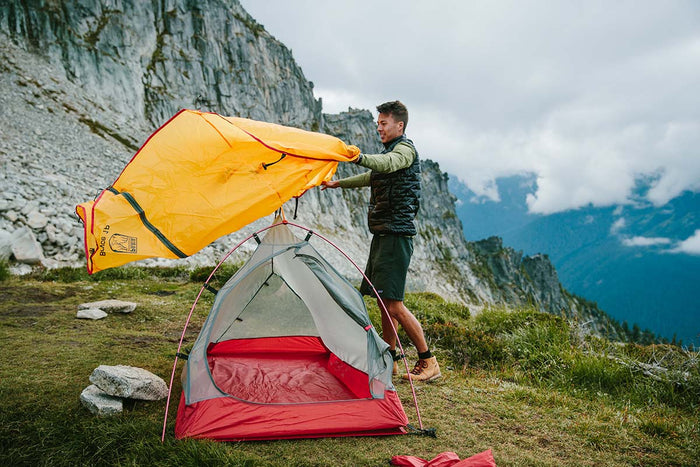
Our Bryce 1P backpacking tent is lightweight and weatherproof, making it a great option for the unpredictable weather along the North Coast Trail.
The North Coast Trail does not tend to get too cold at night during the summer months. As such, you may enjoy the added versatility of a quilt over a sleeping bag.
Pair your quilt with an ultralight sleeping pad to keep your warm and save on pack weight. For added comfort, consider a lightweight, compressible down pillow.
If there's anything else you need to complete your pack, visit our full line of high-quality, affordable backpacking gear.
Shop Backpacking Tents
Shop Ultralight Tarps
Shop Backpacking Quilts
Shop Down Sleeping Bags
Shop Insulated Sleeping Pads
Shop Backpacking Pillow
Shop Folding Trekking Poles
Shop Titanium Cookware
Shop Tent and Tarp Accessories
Finally, to make sure you don't forget something at home, use our Ultimate Backpacker's Packing List. It even includes a convenient printable checklist!
Do I Need a Permit?
Yes, BC Parks charges each person $10 per night to hike the North Coast Trail. Children 6-15 years of age are $5 per child per night. Permits are only required between May 1st and September 30th. There are three ways to pay for the permits:
- Online: https://bcparks.ca/registration/
- Cash: Deposit exact cash amount of Canadian currency into self-registration envelopes at the trailheads.
- Cape Scott Water Taxi: Pay permit fees at the water taxi office at the same time you pay for the water taxi and shuttle.
Permit Fees are not collected during the off-season (Beginning of October to end of April).
Resources
Travel
BC Ferries
Pacific Coastal Airline
Cape Scott Water Taxi
Accomodations
North Coast Trail Hostel
Quarterdeck Inn and Marina
Glen Lyon Inn
Other Resources
Tide Charts at Fisheries and Oceans Canada
Conclusion
The North Coast Trail is a great option for those who are looking for a challenging yet rewarding coastal hike with beautiful beaches. Have you hiked a coastal trail like the North Coast Trail? We'd love to hear about your experience below in the comments!
Read Next
If you're looking for more hike ideas, read our "Best Backpacking Trips on the West Coast" round-up post. Also, the following Hike of the Week articles cover other great trails in the region.
Hike of the Week: Nootka Trail
Hike of the Week: West Coast Trail
Hike of the Week: Della Falls Trail
Hike of the Week: Juan de Fuca Trail
For even more amazing backpacking trips, visit The Trailhead, our interactive hike map. It contains a curated list of dozens of hikes, each with a detailed write-up like this one.

Finally, check out our comprehensive list of backpacking articles that cover just about everything there is to know about backpacking. If you're just starting out, our Backpacking 101 section covers all the basics. If you already have a few trips under your belt, you can find more advanced topics covered in our Expert Articles.


Leave a comment